

Chasing Sunrise: Great Shunner Fell
Kit check passed, at 3:04 am, I step out of the marquee & back onto the trail. Daybreak is close. I can feel it.
I’m excited. The sleep, though short, has refreshed me & I’m looking forward to the climb up Great Shunner Fell. At 2,300 feet, it’s the third-highest summit in the Yorkshire Dales.
I remember the sense of awe I felt here twelve months ago. Those views are etched into my memory, acting as both an incentive & a magnet drawing me upward. I want to watch the sun rise from the summit & I’m convinced I’ve timed my departure perfectly.
But the fell has other ideas.
Just like that first morning back in Edale, the cloud hangs heavy & the clag is thick. It becomes apparent very quickly that there will be no spectacular sunrise today.
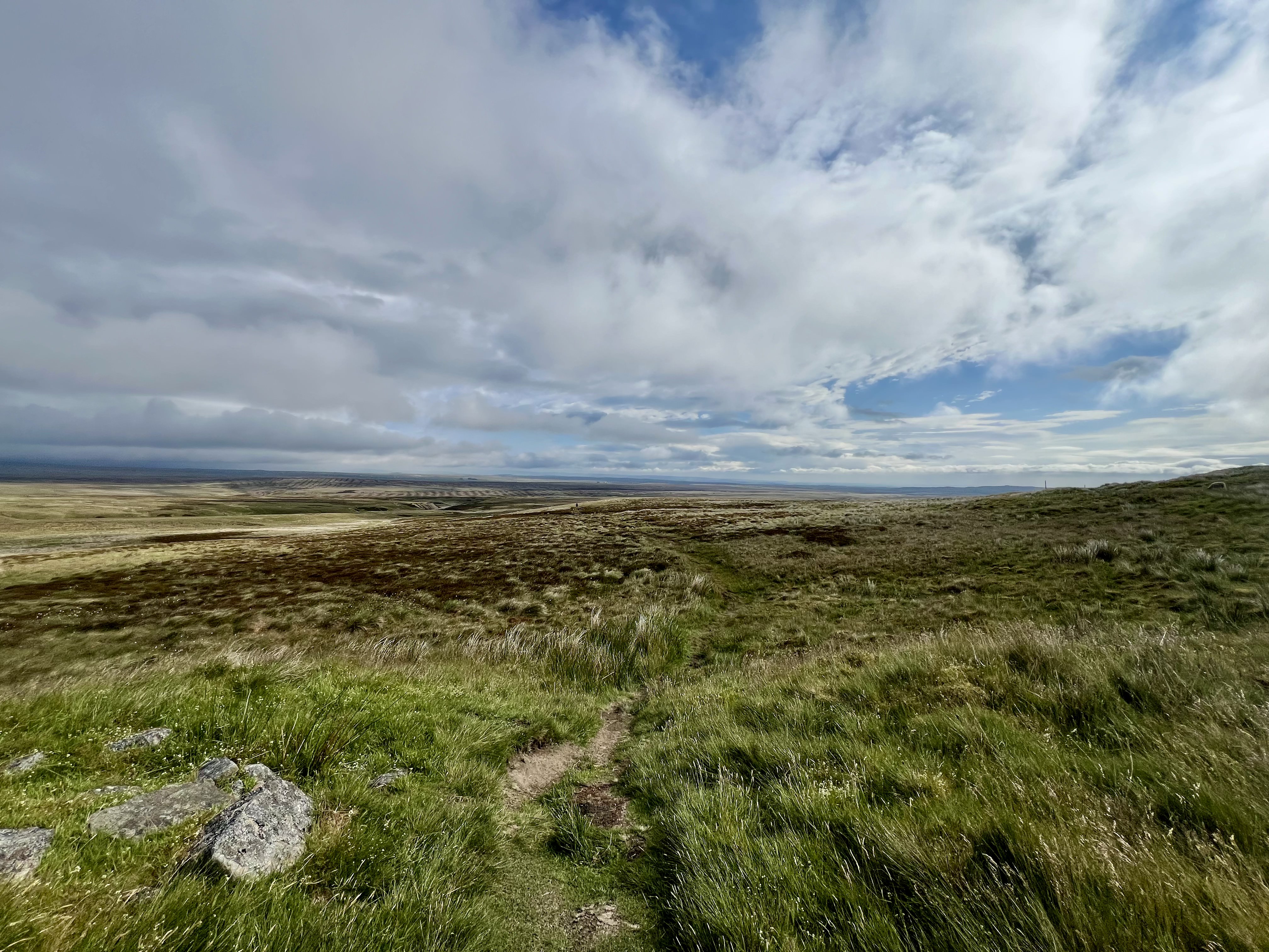
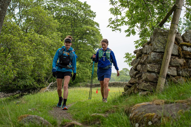
Visibility along the rough farm track out of Hardraw is poor. The path, hemmed in by dry stone walls, is well trodden & relatively easy underfoot, climbing steadily on a gentle gradient. After a couple of miles of continuous ascent, it passes through a gate & leaves the cultivated land behind. Instantly, the landscape feels wilder, more remote.
Beyond the shelter of the walls, the wind hits hard, whipping from all directions. I battle to stay upright. In the early morning gloom, I can barely see the path ahead, let alone the beauty of the Wensleydale landscape I know lies around me.
The stony farm track gives way to a winding ribbon of Pennine Way flagstones, guiding me across boggy moorland. They’re a welcome navigational aid when there’s little else to orientate by, just the occasional fingerpost emerging from the mist.
When the slabs are plentiful, I move well. When they abruptly stop, progress slows. Rocks of every size litter the ground, faint grooves worn into the dirt offering the only indication of the path’s course. There’s no straight line. It zigzags & weaves around bogs: a slab here, a rock there, a small diversion to the right, then back again.
The wind never relents. It’s almost five miles of continuous climbing from Hardraw to the summit & without the promise of a sunrise reward, the ascent begins to drag. And drag. I have no sense of how far I have left to go. I can’t see the top. My earlier buoyancy is steadily stripped away, carried off on the wind.
Then, almost without warning, the summit appears. A large stone windbreak emerges from the clag, marking the highest point & offering some blessed shelter. It would also provide an excellent vantage point, if there were anything to see. Regardless, I sit for a few minutes on the stone bench, savouring the stillness & the sudden calm.
In clear conditions, this summit offers sweeping views across the North Pennines, the Lake District & the Yorkshire Dales.
Today, I see nothing.
I don’t linger. After the long drag up, there’s a long way down, though it’s far from straightforward. The path is rough & rutted, broken by missing slabs, small boggy patches & a couple of stream crossings. But as I descend, the cloud begins to thin & lift & slowly, the landscape reveals itself. Emerging views of classic English countryside unfold below.
The trail merges into a stony farm track, dropping between stone-walled fields into Thwaite, a tiny North Yorkshire village. Here, I’m greeted by two cheerful SST volunteers & an unexpected water top-up.
From here, it’s just three miles to the next mental landmark on my list: Keld.
An initial steep climb across open fields offers a fabulous view back towards Thwaite, before merging into an undulating, narrow path. To my left, a sheer rock face; to my right, a steep drop down to the river. At times, it feels like I’m skirting the edge of a landslide. The trail is a narrow groove between lush green ferns, strewn with loose rocks & stones seemingly placed with the sole intention of tripping you up.
The name Keld comes from the Norse word for “spring” or “well”, & the area is famous for its abundance of waterfalls. It’s also the meeting point of the Pennine Way & the Coast to Coast Walk, now a National Trail.
The Pennine Way doesn’t quite enter the village itself, although in the winter race, a diversion to the village hall to sleep is popular. Instead, it crosses the River Swale & climbs alongside one of the waterfalls before skirting past the settlement.
Somewhere between Thwaite & Clove Lodge, not sure where…
From here, it’s back onto moorland & what feels like a long trudge towards Tan Hill, at 1,732 feet above sea level, the highest pub in Great Britain. I’m still running reasonably well. The section to Keld was my kind of trail; rocky, narrow, weaving singletrack, almost like a coastal path. On 120-mile legs, I perhaps didn’t enjoy it quite as much as usual, but I still far prefer it to long, monotonous moorland stretches.
By comparison, the route from Keld to Tan Hill is very runnable. It rises gently with no major climbs or technical obstacles. On fresh, springy legs, I could cover the four miles quickly. My legs are neither fresh nor springy, but I still manage to run a fair amount, even the final small climb.
I suspect, even at eight in the morning, it’s the draw of the pub.
Tan Hill’s remoteness is striking. Perched high on the moor, almost on a county border, it’s defined by its isolation. There has been an inn here since the 16th century serving packhorse routes. The current building dates back to the 17th century & was originally used by workers from the surrounding coal pits. At that time, it was encircled by miners’ cottages, but when the mines closed in the 1920s, the cottages were demolished, leaving the pub the only building for miles in every direction.
The pub’s function room is open for Spiners. Barrels of water line the bar; there’s a kettle & a small selection of snacks for sale. The room, usually home to weddings, bands & the roar of comedians, is today entertaining tired & dishevelled runners. Runners sprawl around tables & shoes litter the floor whilst the safety team drifts through, quietly checking on us. Someone is snoring on the stage.
I stay just long enough for another bowl of oatmeal & a proper coffee.
On leaving, I’m warned about a dangerous sinkhole that’s appeared in the moorland a few hundred metres beyond the pub. Unwilling to risk someone accidentally falling in, the safety team have marked a safe route around it with red flags. They also suggest keeping goggles close to hand; the wind, they say, is fierce.
I step back out onto the moor with slight apprehension, bracing myself for what’s next.
Grey Clouds
Leaving Tan Hill, the foreboding grey clouds hanging low over the moorland look angry, threatening & ominous. The wind is fierce (though not quite goggle-wearing fierce…), amplifying the exposed ruggedness of the terrain. An untidy, wild mixture of heather, tussocky grass & cottongrass thrashes violently in the gale, offering no shelter at all from the elements gathering above.
I carefully follow the red flags marking a safe route around the sinkhole, then push on, eyes fixed on the white-topped marker posts that guide the way across the vast, open moor.
The Pennine Way traces the meandering line of Frumming Beck, its dark stream carving a deep groove through the peat. Navigation is easier than I remember from last summer, but I still have to choose my steps carefully. Despite the dry season, the path is prone to vanishing into small patches of bog. I can only imagine how utterly soul-destroying this stretch must be in wet, wintry conditions. Sections of boardwalk appear sporadically, seemingly at random. Sometimes it’s there. Sometimes it isn’t.
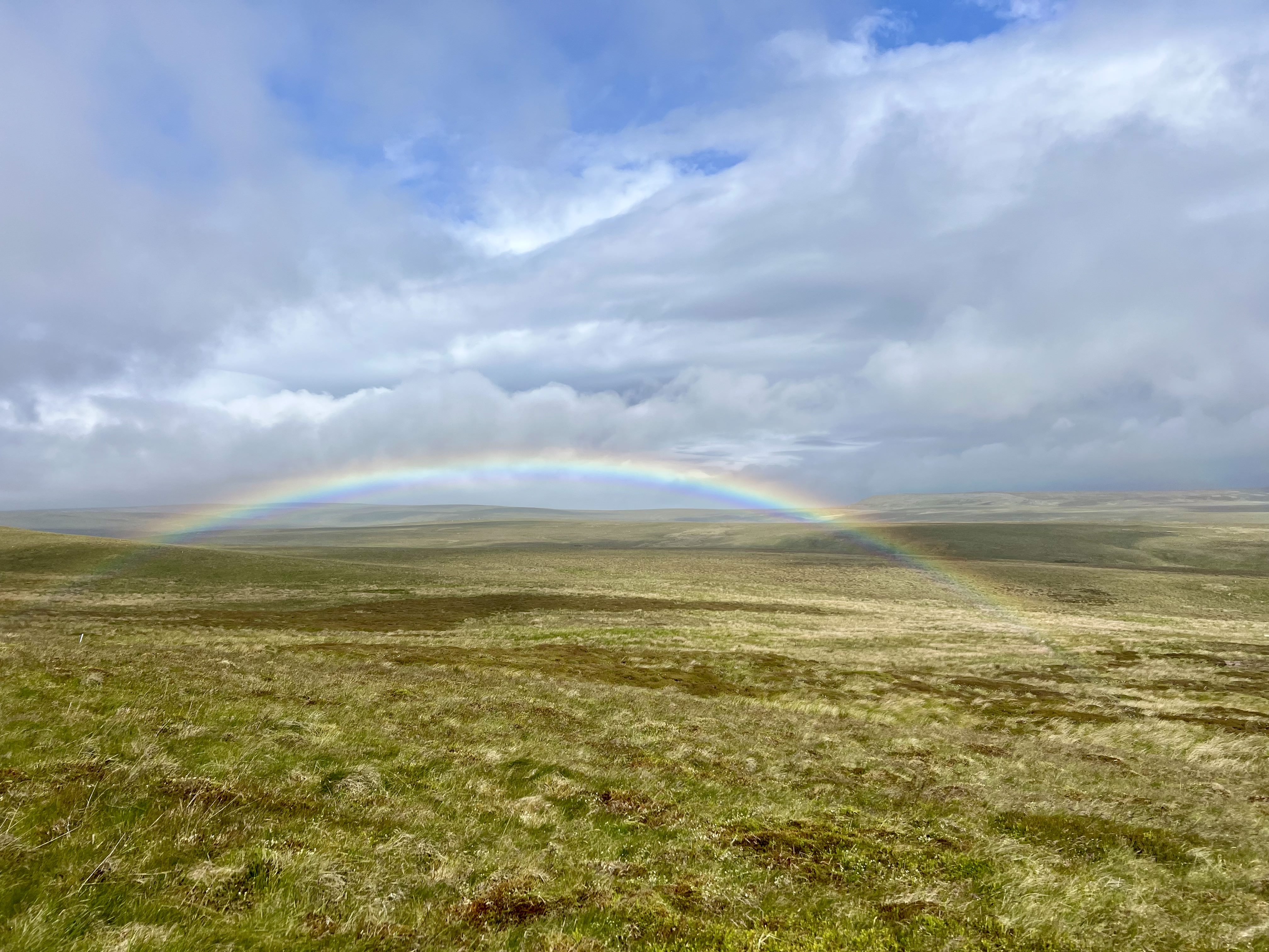
A brief, half-hearted rain shower, not worthy of the waterproof, breaks my stride as I pause to admire a spectacular rainbow stretching from one side of the moor to the other.
Beauty in the bleakness. Worthy of a photo & one of those quietly special Spine moments.
With wide-open vistas & unobstructed views across the desolately flat moorland, I’m suddenly more aware of the other runners around me than I have been for hours. As I cross paths with several, the trail begins to feel busy. It isn’t, of course, but after so much solitude, even a handful of people feels like a crowd. There’s comfort in knowing I’m not alone out here, but even after 120 miles, seeing other runners stirs my competitive instincts.
Feeling good & running well after the break at Tan Hill, I start overtaking a few people.
This will come back to bite me.
Just before Frumming Beck meets Sleightholme Beck, the indistinct moorland path gives way to a hardcore stony track, making the going marginally easier. I pause on the bridge to apply suncream to my face & arms, but for some reason, not my legs. The earlier menacing clouds have blown through, replaced by blue skies & a blazing sun.
The moorland had offered no shelter from wind & rain; now it provides no shade from the heat either. I left Tan Hill around 9 am. It’s now late morning & just like yesterday, the temperature is climbing fast.
I keep moving, trying to capitalise on the residual Tan Hill energy, but the track soon begins to feel monotonous.
A farmyard offers a brief distraction. Running past small cottages, I peer nosily through open doorways, wondering what it would be like to live somewhere so remote, so isolated. The path drops gently towards the River Greta & crosses God’s Bridge, a natural limestone formation & ‘Site of Special Scientific Interest’. I’ll admit, though, it doesn’t hold much interest for me. I’m wilting in the heat & far more concerned with finding somewhere cool to sit.
Just beyond the subway beneath the A66, I find a patch of shade, the first I’ve seen for many, many miles. With traffic thundering overhead, it’s far from idyllic, but I don’t care. I throw my pack down, savouring the sudden weightlessness, strip off the last of my warm layers & reapply suncream, remembering my legs this time. I sit for ten minutes or so. (I didn’t realise it at the time, but I stopped at almost the exact halfway point of the Pennine Way.)
While I’m resting, several of the runners I overtook earlier pass me back. I don’t like this. I know it doesn’t really matter; it’s just the ebb & flow of the race, but the discomfort I feel at being overtaken is a stark reminder of my inner competitiveness. No matter how hard I try to suppress it, I *am* competitive. And being overtaken, even when it’s unlikely to affect the outcome of the race, still stings.
I pick up my pack, but struggle to get going again. Somewhere over the past twelve hours, my lower back has become increasingly painful. I don’t remember exactly when it started, maybe after Hardraw, maybe before. I’m prone to an anterior pelvic tilt, which can cause lower-back issues. I’ve worked hard on my strength over the last few years & it’s been a long time since it’s troubled me like this. Until now. At the worst possible moment. I take a couple of paracetamol, hoping to dull the pain, or at least distract myself from it.
(As an aside, if you look at photos from the latter stages of the race, you’ll notice how rounded my back becomes & how poor my posture looks. I don’t know whether that was the cause or the effect, but either way, it’s something I need to address.)
Just before the grey clouds rolled in…
Whilst ambling up the gentle climb to Cotherstone Moor, I realise I was a little too quick with the suncream.
Grey clouds are rolling back in at speed, the sky darkening ominously. My mood sinks with the light, disappearing along with the sunshine. I pull on my waterproof just as the heavens open. Big, fat raindrops, heavy with negativity, pelt down as I tumble headlong into a deep, dark hole.
I hurt. Splish, splash…
I’m tired. Splish, splash…
I feel sick. Splish, splash…
This is hard. Splish, splash…
I can’t do this. Splish, splash…
I have fallen into a pit of despair. I don’t want to do this.
But I have no choice.
I can’t stop. I have to keep moving.
I know Clove Lodge isn’t far now & it becomes my next mental marker. Get to Clove Lodge. I can stop. Sit down. Have a coffee. Eat some oatmeal. Reset.
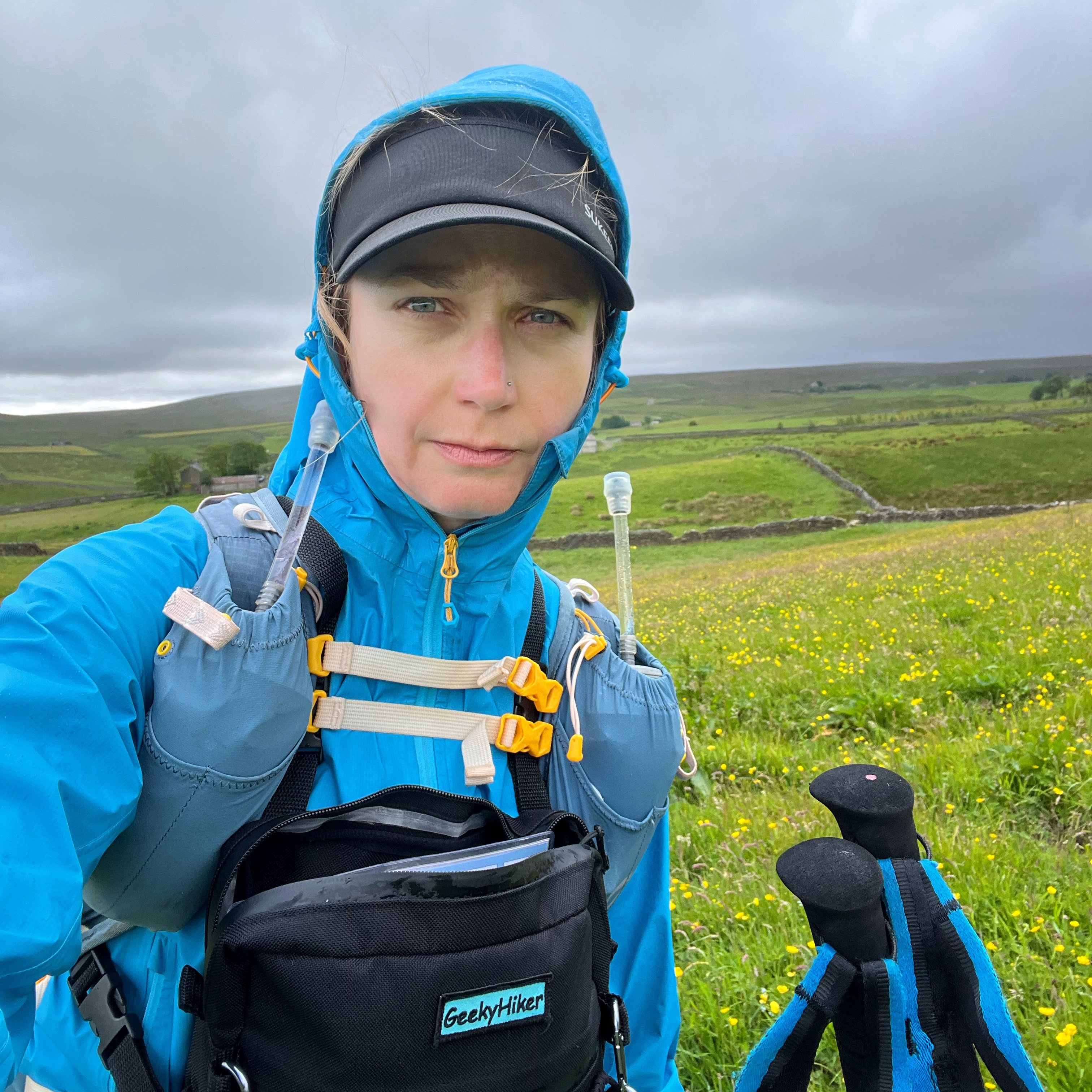
For some reason, I decided to take a selfie of my mood… I guess I wanted to capture the bad as well as the good.
Clove Lodge is a farm sitting directly on the Pennine Way; the trail runs straight through the yard & past the front door. It’s become an iconic haven for walkers & Spine runners alike. A few years ago, the owners converted one of their barns into an honesty café, stocked with snacks, drinks & basic comforts for those passing through.
There’s a tap for refilling bottles, a kettle for hot drinks & even a couple of mattresses for weary travellers. As I arrive, a few Spiners are already making use of them. It’s busy, seven or eight runners clearly had the same idea during the storm, along with a very talkative non-Spiner heading north to south, who seems rather fond of the sound of his own voice.
There are bananas on the table, so I grab one to go with my oatmeal, along with a can of Coke, dropping a few coins into the honesty box. There’s plenty of food available, although sadly, very little of it is vegan.
I sit quietly for fifteen minutes or so, eating & drinking. My mood is still heavy, but nourishment lifts it slightly. It’s eight miles from here to checkpoint three, just past Middleton-in-Teesdale. When I get there, I can rest properly. I can eat properly. And I can, hopefully, sleep.
I leave Clove Lodge still wearing my waterproof, even though the rain has eased. A gentle descent leads towards Blackton Reservoir & past Hannah’s Meadow. Once belonging to Hannah Hauxwell, the Yorkshire shepherdess who became known in the 1970s for living here without running water or electricity. The meadow has never been treated with fertilisers or pesticides; as a result, it’s now a haven for rare species & protected by the Durham Wildlife Trust.
From Hannah’s Meadow, the route dissolves into a series of nondescript, undulating miles. Moorland. Fields. Sheep. More fields. More sheep. Up. Down. Gradual climbs that are just slightly too steep to run. With no major landmarks, the miles drag. It becomes tedious. I’m fed up. I’m grumpy. I’m in a deeper, darker hole than I was before Clove Lodge.
Then my right knee starts to hurt.
My back has eased, but now it’s my knee. It’s genuinely painful & running becomes harder by the minute. I fixate on it, catastrophising. I replay the day, searching for a cause. I haven’t fallen. I haven’t twisted it. I haven’t done anything.
And yet it hurts.
It hurts.
It hurts.
It consumes everything.
I reach the outskirts of Middleton. I know the checkpoint lies a deceptive two & a half miles beyond the town. Passing the campsite where Rel & I stayed last summer briefly lifts my mood, but the pain drags it straight back down again.
The path skirts the town centre and follows the River Tees. It’s relatively flat & I convince myself I’ll reach the checkpoint faster if I run. So I do, despite the pain.
It’s a beautiful stretch of trail. The river sparkles invitingly to my right; lush green fields & wildflowers sway to my left. But I barely notice any of the beauty. Head down. Blinkers on. Teeth clenched. I need the checkpoint. I need rest. I need my knee to stop hurting.
As I finally spot the Spine flags fluttering in the distance, I cross paths with Catherine again. We walk the final five hundred metres together, chatting as we go. She’s the first person I’ve spoken to properly since Tan Hill, however many hours ago that was. Those few minutes of conversation lift me & I find myself walking into the checkpoint with a bounce I thought I’d left somewhere back on Sleightholme Moor.
I wonder what the past eight miles might have felt like if I hadn’t been quite so stubbornly solo.
Caught by a Spine photographer walking with Catherine into the checkpoint.
Low Way Farm, Middleton | Checkpoint Three
Middleton checkpoint, housed at Low Way Farm, is once again a collection of tents pitched in a field, with the main dining area set up in one of the small farm buildings.
The room is cramped: four long tables with benches running along either side, runners slumped wearily into every available corner. Drop bags in varying states of disarray are strewn across the floor, while volunteers drift in & out carrying steaming plates of food & endless cups of tea.
Hungry, I scan the menu.
Vegan curry & rice.
My stomach turns. As hungry as I am, I honestly can’t think of anything worse to eat in the middle of a very long run than curry. I ask if there’s an alternative & am offered breakfast instead: beans on toast.
Much better.
As I work my way through the first of several portions, I speak to one of the medics about my knee. It’s really worrying me. She can’t see or feel anything obviously amiss, so she suggests that I rest, get some sleep & check back in with her before I leave.
With my appetite satisfied, I’m guided to a tent behind the farm building. There is the option of a proper bed in the shared bunk room upstairs, but you’re not allowed to take your drop bag up with you.
And I want my drop bag.
I might sleep better in a bunk than in a tent, but there’s a fine balance between physical rest & mental rest. For my mind to settle, I need my drop bag. I need to work through my task list. I need to tick things off. I need to know that I’m physically ready to head back out onto the trail, because if my mind is anxious, my body won’t rest.
Just like at Hardraw, I methodically work through the list. Electronics on charge. Snacks refilled. Freshen up.
Only this time, there are proper toilets.
And running water.
They’re not exactly luxurious, essentially a dusty brick shed around the back of the farm building with the smallest of hand basins & the dimmest of lights. In a trickle of tepid water, I manage my first proper wash since Sunday morning. I scrub away layers of grime, dust, mud, sweat & sticky suncream residue.
It feels glorious.
Clean again, I pull on a full set of fresh kit. Everything from underwear & socks to shorts and T-shirt. The simple joy of feeling clean(ish). I head back to my tent, repack my drop bag, check the charge on my electronics & tick off the last remaining tasks.
My mind finally settles.
Now I can rest.
It’s late afternoon. The sun has warmed the tent & I don’t need my sleeping bag. I unzip it to lie on & drowsily snuggle down, ready for sleep.
Only the sheep have other ideas.
I don’t know whether they’re protesting at the tents in their field or noisily reminding the farmer that it’s dinnertime, but the buggers do not stop bleating. It’s loud. It’s disruptive. And bar (pun intended) an unsettled half-hour or so, it ruins any chance of proper sleep.
After about an hour of tossing & turning, I accept defeat. There’s no point just lying here. I clear the tent, shoving my sleeping bag & last few bits back into my drop bag & wander back to the dining room.
I’m hungry again.
Over two more rounds of beans on toast, the medics reassess my knee. It still hurts. There’s some inflammation, but little else to go on. They tape it for extra support & give me codeine, a stronger painkiller than the paracetamol I’ve been relying on. While my knee has now taken centre stage in the pain stakes, my back is still sore. I tried stretching it out in the tent, with little success.
One hundred and forty-three miles in, I start to worry that my body might be giving up on me.
Drop bag deposited, I sail through kit check and take a few minutes to phone the husband whilst I mentally prepare for the next section. What lies ahead is possibly my favourite part of the entire Pennine Way, but it’s also one of the most technical & demanding. I’d hoped to tackle it in daylight.
It’s just gone 9 pm. There are 90 minutes of daylight before I head into night three.
- Checkpoint 3. Low Way (Middleton).
- Distance covered: 143 miles
- Arrival time: 16:24:12, Tuesday 17th June
- Race time: 56:23:57
- Time in checkpoint: 04:50:09
Next up: Summer Spine Part IV | Middleton to Alston
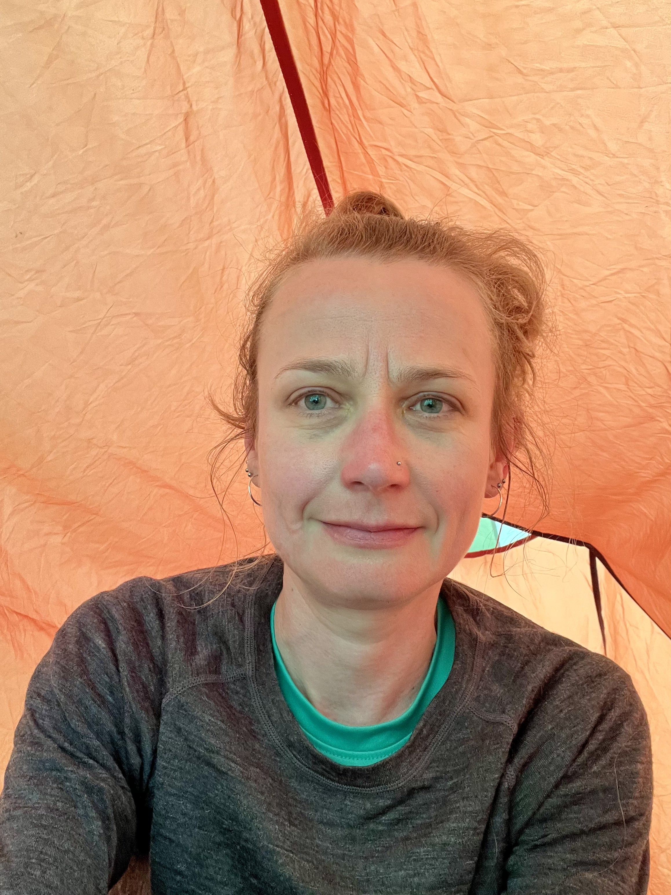
The rawness of my exhaustion, in my tent at the checkpoint.
